The “miles” thing is hairy. With boots on your feet and a pack on your back, you tackle the trail in front of you, and the same miles on the same trail will be more or less the same miles for the next hiker.
It’s not like that in a sea kayak. Last summer in the Apostles, we cruised 18 miles from Manitou Island to north Outer before 2pm with a 12 knot tailwind. We could’ve gone farther, easily. Two autumns ago, it took us three hours to crawl the last five miles into Washington Harbor with a stiff cold headwind. There's wind, and waves, and current, and all of that changes the meaning of a mile.
There’s also the coastline paradox— Because of infinitely smaller measurements of bays and coves, tiny indentations in the land, fractals of rocky features, coastline by nature cannot have a concrete measure of distance.
For a sea kayaker, miles aren’t the most useful gauge of progress or difficulty, and they don’t tell you much about the route. All this to say, take the milage totals with a grain of salt. This milage total also doesn’t include all the times we’ll have to double back for something Andy’s forgotten.
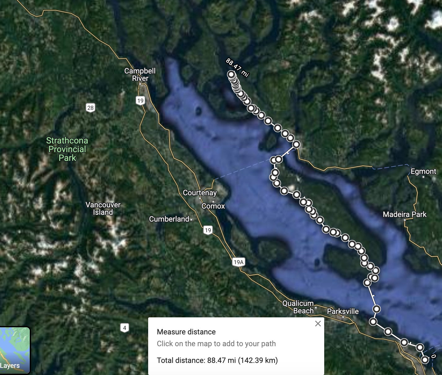
And so, you’ll notice that the milage total on the image above (1,184.61 mi) is wildly different from if you sum the milage of the individual sections below (1,600 mi). This is entirely due to the coastal paradox; in the first measurement I took the shortest possible route, cutting bays and coves, following the route generally. In the measurements below, I went into every bay and cove, added in the milage of potential side trips, leading to a difference of almost 400 miles.
How far are we going? 1300 ish. But the miles aren’t that important.
Grand total: 1,100- 1,600 miles
We expect to cover 15-25 miles on good days, and whatever we can on bad days. The current route is a meandering path, guided a lot more by interesting points than quickest route north. Some of these detours might be cut out in order to hit weather windows, and the route as a whole is subject to change— it’s about having a good time, and living out of a kayak, not reaching a specific spot in a certain amount of time. Still, I like to have the spine of the trip on paper. We’ll have most of May, June, July, and August to get to to where we’re going, which is very generally north.
Part One: Discovery Islands
Note: I used First People’s Map of BC to identify Indigenous Territory (which is all of the American Continent). I’m certainly not an expert on Indigenous history, and definitely not on Indigenous Languages, but it’s impossible to paddle anywhere without thinking about the people who have paddled there for 10,000 years.
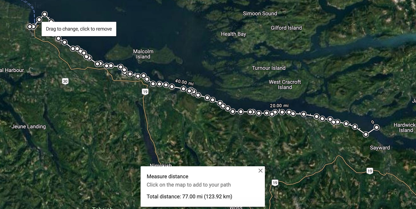
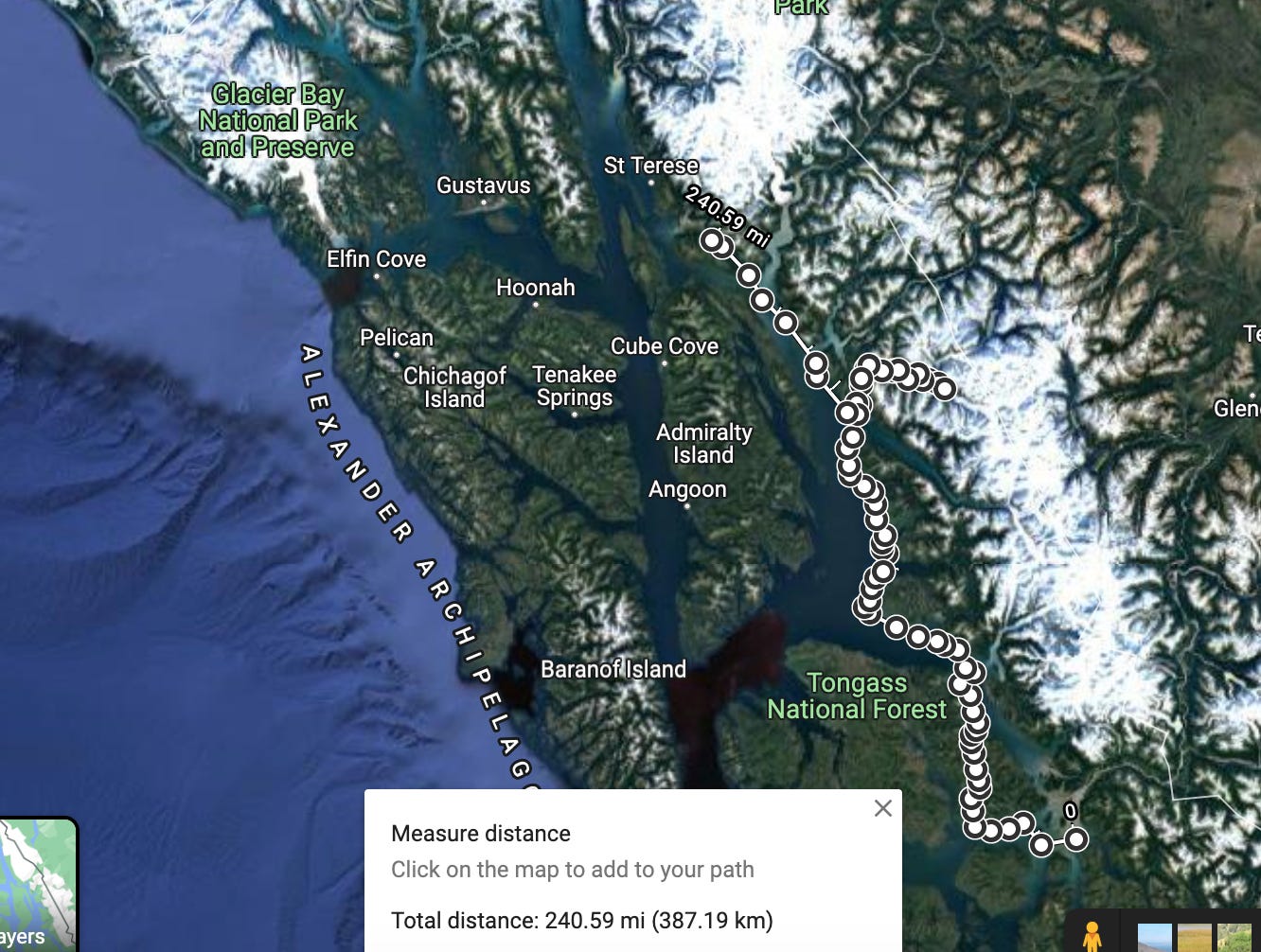
screenshots from Google Maps.
San Juan Islands: Coast Salish & Lummi Territory
Launch day will be mid-May from Bellingham Harbor, and we’ll head out through the Northern San Juan Islands in the Salish Sea. Highlights of the San Juans include pretty campsites, Douglass Fir trees, seals, sea lions, otters, and of course, the orcas the islands are known for.
Hazards include shipping corridors, tide rips, and the mid-May temperatures (40-50 degrees F). Average milage for this portion of the trip will be a very attainable 10-15 miles a day. We’re planning on spending 4-5 nights in the San Juans before crossing the border. None of us have been out seriously paddling (except maybe Andy, who’s been kayak surfing a few times) this winter, so these few days in US waters with lower milage will give us a chance to get back into it.
Kayak trekking, at least how we’re taking those first few days, doesn’t actually require decathlon amounts of physical fitness, thank god. Rather it requires enough physical fitness (or at least mental fortitude) to keep paddling, ability to handle a heavy boat and haul gear, and good judgement. There are plenty of guided tours available in the San Juan Islands, both day trips and overnights, and this section is totally attainable for beginner sea kayakers with a guide!
Total Days: 4-5
Total Miles: 65
Gulf Islands: Coast Salish, Snuneymuxw & Saanich Territory
From the San Juans, we’ll cross the border and head directly to customs at Sidney, BC, then continue north into the Gulf Islands. The Gulf Islands are also part of the Salish Sea, and have much of the same wildlife and climate as the San Juans.
From the Southern Gulf Islands, we’ll head north to Nanaimo, then tackle the 11 mile crossing of the Strait of Georgia to Lasquetti Island. The crossing is broken up by a few small islands into a 3-mile, 6-mile, and 2-mile crossing. We’ll need to wait for a decent weather window to tackle this, especially due to the boat traffic in the strait, and we’ll try and leave early in the morning.
This section will be approximately 6 days, weather dependent, with a potential layover day on Saysutshun Island to restock on food.
Total Days: 4
Total Miles: 60
The Sunshine Coast: Tla’amin Territory
Okay, so technically we’ll be northwest of BC’s Sunshine Coast, but we’ll certainly be in the neighborhood. Plus, I was reading up on the Sunshine Coast Trail (SCT) and was reminded of the SHT and felt inspired to name this section so. Plus, wishful thinking.
Here, we’ll head north along Texada Island then cross to Powell River for some municipal campground goodness and a shower, and maybe a pizza.
Oh, hey! Good time to plug that if you want to contribute to our pizza fund this summer, become a paying subscriber of Hello Stranger by smashing that button below! You’ll get access to a backlog of essays & PDF hiking guides, a download of my book, Hidden Gems of the Northern Great Lakes, and will be the first to know when s*%t hits the fan this summer!
After Powell River and some greasy food, we’ll continue north towards the Copeland Islands, eventually probably having lunch on a beach that intersects with the SCT, which is now on my bucket list. Here’s a great blog post on the Sunshine Coast Trail hiking route.
Total Days: 7-8
Total Miles: 90
Discovery Islands: Homalco, Kahoose, Da’naxda’xw and Kwikwasut’inuxw Haxwa’mis Territory
From Sarah Point we’re off north to the Discovery Islands. We’ll have an optional detour into the Teakerne Arm, the first waterfall of the trip!
Discovery Islands are another world-class sea kayaking destination, particularly for sea kayak surfing. Here in the Discovery Islands, the moon drags the ocean around all of Vancouver Island and through the passages of Discovery, creating some of the gnarliest tidal rapids in the world. Our goal is not to paddle those (this time). We’ll have four tidal rapids to negotiate on this leg, the gnarliest being the back to back Yaculta and Dent rapids. This will involve timing our passage for slack current, or the time around high or low tide when the water is neither ebbing nor flooding. Watch a video of Dent Rapids below. (I’ve figured out how to embed things, game OVER!)
Definitely the currents/rapids will be the biggest hazard of this stretch.
Total Days: 5-6
Total Miles: 75
The Johnstone Strait: Namgis, Gwa'sala-'Nakwaxda'xw, and Da’naxda’xw Territory
From Hardwick Island we’ll cross back south to Vancouver Island, following the southern shore of the Johnstone Strait north to Port Hardy. This will probably be a quick four day stint. The Johnstone Strait can get rowdy with 70 some miles of fetch to the northwest, and is home to about 150 orcas in the summer.
Here, there’s a good chance we’ll see orcas and tourists, trying to see orcas. From here, we’ll resupply in Port Hardy, maybe take a shower if we can find a hotel for a night, then hop back in the boats and continue north.
Total Days: 3-4
Total Miles: 70
Part Two: BC’s Wild Coast
Cape Caution: Gwa’Sala-‘Nakwaxda’xw Territory
So comes that part of the trip I am inevitably most worried about. Cape Caution is one of the few sections of the route exposed to open ocean, and is pretty notorious. Reefs around the area make for crashing swell, rebound waves, and a good 16 miles of essentially un-landable coast. Sea Kayaker horror stories include a crash landing in Burnett Bay where all four paddlers capsized; one had to be evac’d due to a sliced finger on a rudder cable, and another was tumbled in the surf for quite sometime without the aid of a PFD (wear your PFD, no matter how nice out it seems!!). Other accounts include 20-30 ft swell, which I would like to not be in, and getting windbound at Burnett Bay for days.
We’ve got wiggle room to work with time-wise, so we’ll be playing this section extremely conservatively. We plan to not stop at Burnett Bay, (does anyone have a good story about Burnett Bay?), and instead camp in a protected area to the south, and paddle Cape Caution at the crack of dawn. Or, if needed, we can take a ferry from Port Hardy north to Bella Bella, cutting out this and the next section, about 150 miles. While we’d like to paddle through, there’s no point in needless suffering.
Total Days: God only knows
Total Miles: 90
Hakai: Wuikinuxv and Heiltsuk Territory
From Cape Caution north into protected waters of the Hakai Pass, we’ll head north to Bella Bella/Shearwater either along the mainland side of the Fitz Hugh sound, or cross out to Calvert Island and island hop north. Likely we wills stick to the coast to make the most of the prevailing wind patterns in the summer.
We’ll resupply in Bella Bella.
Total days: 3-4
Total miles: 66 miles
Fiordland: Kitasoo / Xai’xais and Gitga’at Territory
Fiordland, BC is probably the part of the trip I’m looking forward to most. Guidebooks promise waterfalls off cliffs, deep and beautiful fjords, and limited landing/camping opportunities. Oh, and grizzly bears. Oh my.
This 135-mile stretch includes one of our first major detours from the traditional Inside Passage route, tacking on about 20 miles to visit Kynoch Inlet and the Pooley Island Area. This route will take us closer to the heart of the Great Bear Rainforest. Ideally, we’ll work our way north towards the Grenville Channel over the course of one week.
From there, it’s another 4-5 days north to Prince Rupert
Great Bear Rainforest
The Great Bear Rainforest runs from the Discovery Islands all the way north to meet with the Alaskan Panhandle and become the Tongass, so this section title is misleading. The Great Bear Rainforest is most notably home to Kermode Bear, or “spirit bear” a white subspecies of black bear. According to Wikipedia, there are only 100-500 individuals and their found around Princess Royal Island. Still, I have no desire to see a bear of any kind.
We also have a potential detour up into Kitimat and toward some of the hot springs in the area. It might be that we end up spending closer to a month exploring this area of BC, and forgo some of Northern Alaska. You could probably spend a lifetime exploring the Inside Passage; we’re lucky to have 3 1/2 months.
Total days: 11- 16
Total Miles: 236 miles
Part 3: Alaska
Dixon Entrance: Gitxaala, Metlakatla, and Lingít (Tlingit) Territory
The Dixon Entrance is the second and last portion of the trip we’ll spend exposed to open ocean. We’ll enter the Alaskan wilderness and head north to Ketchikan. By this point in the trip, the goal is to push for some higher milage days and become lean mean kayaking machines.
Ketchikan is often used as an endpoint for Inside Passage paddlers, though the traditional end is either Glacier Bay or Skagway. We’re lucky to not be dealing with “real world constraints”, and that’s intentional. We don’t have to be back by any certain date for jobs, or anything like that, but likely we will be off the water by the end of August simply due to impending changes in weather.
Total Days: 7
Total Miles: 114
Ketchikan to Wrangell: Lingít (Tlingit) Territory
From here it’s on to Wrangell, in search of another pizza (can you tell I’m writing hungry?). Much of the Alaska sections are less written about and less visited, so while I have a route, I don’t necessarily have detailed highlights or a good picture of what this section will look like.
I’m a planner— I like to have everything researched to the point that I feel like I know the area before I even go. That level of research doesn’t really exist for this section, and that’s okay— it’ll feel more like actual exploring, with surprises rather than points of interest in my little notebook.
Total Days: 5 (optimistic, let me dream)
Total Miles: 113
Tongass:
From our pizza stop in Ketchikan, we’ll cruise north toward Juneau, which took me six attempts to spell. Bears will continue to be a high concern, but hey! Alaska! Potential detours include the Tracy Arm, and deciding if we’ve got the time and wherewithal to continue North.
Total Days: 12
Total Miles: 240
The Slog:
What we do from here will really depend on how much time we have left. We’d like to finish up in Glacier Bay. That would be really cool. We’ll have already paddled more than 1,000 miles, and this would add another 400 some. It’s hard to say if we’ll want to or be able to push that much more.
Total Days: 5
Total Miles: 80
Part Four: Glacier Bay and maybe Haines
For another delightful 300 miles and 15 days, we could add on a little trip up into the arms of Glacier Bay National Park and then on to Haines, Alaska.
As written up, this would put us at about 94 days, not including windbound, but including a few planned layovers. We’ve got no set end date, but will likely need to be off the water just weather wise September first, giving us 105 some days from May 15th.
It’s cheesy to say “it’s about the journey not the destination”, but it’s also healthy and I think the right and safest way to approach any wilderness trip. The route isn’t about the catharsis of paddling 1300 miles to end at a the face of an Alaskan Glacier— the miles don’t matter, the arbitrary destination doesn’t matter, but the days themselves, beautiful campsites and horrible headwinds, backcountry meals and wildlife sightings, those will matter.
It’s snowing again outside right now, on April 26th, and I just can’t wait to wake up with my head on the ground every morning, to have stiff shoulders and smile lines. We’re launching in about two weeks. Wild.


Maddy, I have family in Wrangell, Alaska. I would love to connect you with them. I replied to the email update from this blog post, but maybe that doesn’t really get to you. Let me know the best way to get you their info.